TNTmips Specifications
TNTmips Review

by
Last Updated: 2020-03-19 21:48:59
With temperatures in flux all around the world, heatmaps may be incredibly useful to keep track fo everything. However, there aren't too many programs out there that can help you with it, and most of them are localized heatmaps. If you want to analyze the heat of the world along with a ton of other data, then you need a special program for it. One of them is TNTmips.
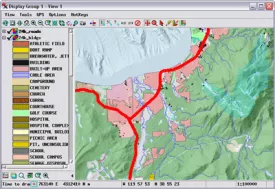
Installing TNTmips is incredibly easy. Simply run the executable and you're good to go. Once you boot it up, you'll notice a ton of different things on the UI. It might get a little overwhelming.
This program lets you create complex maps, using various types of objects for visual reference. You can process data that is already in digital form, as well as import scanned physical maps and create rasters and geometric objects. Once you have loaded a raster image of a physical map, you can trace contour lines to create vectors that offer digital representations of elevation data, watersheds, terrain types and many others. You can then label the created contour lines and assign values to each of them.
There is a ton of other features as well. It also has surface modeling features that let you create a 3D representation of natural terrains and mathematical surfaces. All in all, if you want to analyze maps in way more info than most people would ever need, then you should give TNTmips a download. It does its job well and will serve you well.
DOWNLOAD NOW
At the time of downloading TNTmips you accept the terms of use and privacy policy stated by Parsec Media S.L. The download will be handled by a 3rd party download manager that provides an easier and safer download and installation of TNTmips. Additionally, the download manager offers the optional installation of several safe and trusted 3rd party applications and browser plugins which you may choose to install or not during the download process.


